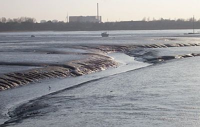
Langstone Harbour
 Portsmouth, Langstone and Chichester Harbours are the flooded valleys of the ancient
Solent River system. The harbours remain here because of the buffering effect of the Isle
of Wight. Without the island, the English Channel may be lapping up against Portsdown Hill.
Within the harbours, mudflats and saltmarshes develop because of the protection
from the sea's energy. Langstone Harbour covers an area of about 1900 hectares (4700 acres) between Portsea Island to
the west and Hayling Island to the east.
Portsmouth, Langstone and Chichester Harbours are the flooded valleys of the ancient
Solent River system. The harbours remain here because of the buffering effect of the Isle
of Wight. Without the island, the English Channel may be lapping up against Portsdown Hill.
Within the harbours, mudflats and saltmarshes develop because of the protection
from the sea's energy. Langstone Harbour covers an area of about 1900 hectares (4700 acres) between Portsea Island to
the west and Hayling Island to the east.
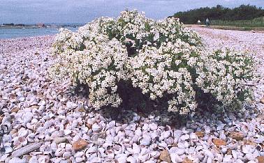
Waves and tides give rise to some interesting effects
on the distribution of materials. On the east side of the harbour entrance (pictured right) is a
huge bank of Slipper Limpet shells, topped with plants of Sea Kale. These molluscs were
introduced from North America, and now cover extensive areas of the sea-bed in the Solent.
Mud
Mudflats are a highly productive system. Living in the mud are millions of invertebrates,
ranging from tiny non-segmented and segmented worms up to the King Rag Worm, which can be 30cm long.
Green algae such as Enteromorpha intestinalis, commonly called Gut Weed, grows over the surface
of the mud. Saltmarsh plants such as Glasswort and Eel Grass have roots into the mud. These plants and
the algae are fed on by Wigeon and Brent Geese. The algae also support high densities of Laver Spire
snails, Hydrobia ulvae and other molluscs.
In turn, these animals support fish, other marine animals, and a wide variety of wading birds and wildfowl.
However, the Gut Weed is not without its problems, because it tends to smother the mud flats with an algal mat and makes life difficult for the mud-dwellers. It is not clear whether the recently improved sewerage system is reducing the amount of Gut Weed.
Marine Life
Marine habitats are by their nature more difficult to survey than places on dry land. Fish commonly found in the harbour are believed to include Eel, Bass, Blenny and Flounder.
At certain times of the
year, Grey Mullet, Plaice, Herring and Mackerel are amongst the visitors. The harbour, along with
Portsmouth and Chichester Harbours, is designated as a Bass Nursery Area. It is also a useful
breeding ground for fish where there are weeds and submerged structures such as the old Mulberry
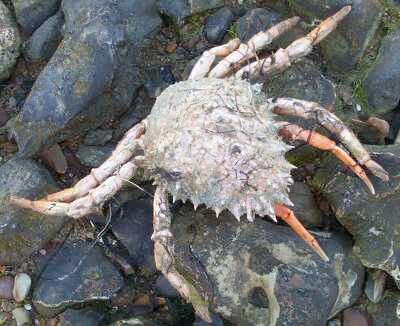
Harbour. This edifice is rumoured to be home to the mighty Conger Eel. An idea of the shellfish in the
harbour may be had by a bit of beachcombing. At the entrance to
Eastney Lake, near Milton Lock, is a colony of Edible Periwinkle. They are not necessarily safe to eat.
Shells of Common Cockle, another intertidal species, can be found in various places.
Pictured right is a Spiny Spider Crab that had been washed up onto the beach. These can also be found on Southsea Beach.
Common Seals are sometimes seen in the harbour. They can be distinguished from Grey Seals by the shape of the head. The Common has an in-curved profile, while the Grey has more of a Roman nose.
Pebbles
Look at a section of chalk cliff, for example at the top of Paulsgrove chalk pit, or where the A3M motorway cuts though Portsdown Hill at Bedhampton, and bands of flint can be seen, occupying only a small fraction of the total height. It is hard to believe that these narrow bands can be the source of most of the pebbles in this area. Vast quantities of chalk deposits and their bands of flint have been eroded away from above the present ground surface, allowing the flints to be worn down into pebbles which now form the beaches and parts of the sea-bed.
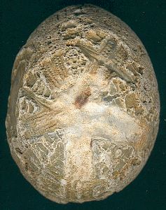
On the left is a fossilised Sea Urchin, now made of flint. This one was found at Broadmarsh in Langstone Harbour. Fossils like this are probably easiest to find in the harbours where the pebbles have not been subject to constant wave action, and are therefore more angular than the rounded ones on Southsea and Eastney beaches. It may also be best to look during winter, when there is less growth of seaweeds.
Designations and Management
Langstone Harbour and some surrounding areas have various environmental designations. The harbour
itself is a Site of Special Scientific Interest, a candidate Special Area of Conservation, a
Special Protection Area
for birds, and a Ramsar site.
See DesignationsĀfor more general details.
The Langstone Harbour Board has the
task of controlling boating and fishing activities in the harbour and have more recently taken
on the promotion of nature conservation work. An environmental officer is now employed.
John Goodspeed has details and photos of
the activities of the Friends of Langstone Harbour, and more general information on the harbour.
Adjoining areas
The RSPB Islands and Hayling Oyster Beds are valuable roosting and breeding areas.
Farlington Marshes at the northern end is a nationally important
coastal grazing marsh, managed as a nature reserve.
Milton Common provides good views of the harbour from the west.
The coastline seen today was created in the 1970's by infilling Milton Lake.
Milton Locks Reserve is a small remnant of natural coastline adjacent
to Eastney Lake, which is part of the harbour.
Broadmarsh (SU703053) and South Moor (SU708049) are good viewing points at the northern
end of the harbour.
Further Resources
The Wildlife of Hayling Island, by Pete Durnell and John Walters. 2001
Hampshire's Countryside Heritage series, No. 7, The Coast. Hampshire County Council. 1984
Eurobirding web site on the harbour.
Back to Sites